JEEP TRAIL OFFROAD GPS: What GPS is everyone running?

Yep. And I also use an app called TrailConnect on my iPhone. When we go hiking also, you can go into the app and look at everything before hand with wifi at your home and the maps will save in the app to use when you're offline. Can be a good tool for when you're a bit deep into things and you don't have any service.


Sent from my iPhone using WAYALIFE mobile app

Oooooo!! I'm going to have to download and play with that! Thanks for the info!

Looking forward to seeing what others say on this subject as well.
 
While all these are great tools never use these to substitute what your seeing in front of you. All too often we hear about someone who paid the ultimate price by listening to their GPS or other app and not paying attention to what they see in front of them. Also some of these apps or google earth may lead you onto private property. 90% of the time no one will ever know but that 10% may have an angry gun wielding individual. If there is ever a doubt find a local land management office weather it be county, state, or federal. They have a lot of valuable info and most of it is free as well. Illegal use is what leads to trails or entire areas getting closed. Conservation groups tend to have deep pockets with good lawyers. OK sorry for my PSA on responsible land use and back to your regularly scheduled thread..haha.

Sent from my 831C using WAYALIFE mobile app
I agree 100%. It is almost too easy to forget at times. Nothing can replace common sense.

John Rumph- Alpharetta, Ga
 
In Jeep GPS for navigation

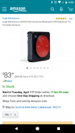
Anybody added an aftermarket GPS unit to the Jeep? My 430N gave out and I'm thinking of buying a GPS to send location data via Bluetooth to an iPad mini I'm mounting.

Right now looking at this one.

Screenshot_20170409-163449.png
 
I looked into one of these and using my iPad as well. Lots of info out there in expedition groups. However, I changed my mind after taking my iPad with me on a couple runs (for music.) With the top down and doors off, it gets too hot. Slows down, battery dies faster, hard to see, and gets slow and crashes. Too frustrating. Also, the apps, or apple's software always seems to want to update at the most inconvenient time.

I think the best option for me is one of the Lawrence units.

Been using mine for 5 years with no issues.


Sent from my iPhone using WAYALIFE mobile app
 
I looked into one of these and using my iPad as well. Lots of info out there in expedition groups. However, I changed my mind after taking my iPad with me on a couple runs (for music.) With the top down and doors off, it gets too hot. Slows down, battery dies faster, hard to see, and gets slow and crashes. Too frustrating. Also, the apps, or apple's software always seems to want to update at the most inconvenient time.

I think the best option for me is one of the Lawrence units.
You referring to the iPad in regards to these issues?
 
You referring to the iPad in regards to these issues?

Yes. I was using MotionX in my iPad Mini. I still use it once in a while on evening trips.

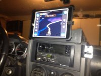
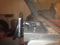
My mount and case doesn't provide adequate airflow to keep it cool during hot days exposed to sunlight.

IMG_1039_zps8fe13b04.jpg
IMG_1040_zpsfae422ae.jpg
 
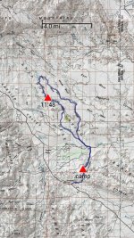
I use an app called backcountry navigator pro and really like it. I think the app was $10 and it works great. You can pre download all types of topo maps in advance, from Forrest service to USGS etc. Make waypoints and points of interest etc.

Here is an example from this weekend.

10-04-17_08-13-09.jpg
 
Just to clarify, I'm not looking for app or tablet recommendations. I'm looking for external GPS recommendations to use with my iPad mini. See OP.
 
In Jeep GPS for navigation

I have a Delorme InReach explorer. Paired with an iPhone or tablet with the Earthmate app it works pretty good.

Pros. Crazy long battery life. Tough as nails and water proof. Send/receive text messages with coordinates. SOS personal locating beacon service. Pairs with devices via Bluetooth.


Cons. Price! It's like 450 bucks just for the unit. Then there are various subscription plans to use the satellite services. Not the best app for navigation.
 
Last edited:
I have a Garmin InReach. Paired with an iPhone or tablet with Garmin's app it works pretty good.

Pros. Crazy long battery life. Tough as nails and water proof. Send/receive text messages with coordinates. SOS personal locating beacon service. Pairs with devices via Bluetooth.


Cons. Price! It's like 450 bucks just for the unit. Then there are various subscription plans to use the satellite services. Not the best app for navigation.

iPhone 2G has an app for that?


Sent from my iPhone using WAYALIFE mobile app
 
Can't really help you here, cause I'm in the same boat. As far as affordable GPS goes for iPad or phone is the one you listed or BadElf, or the Garmin version. I was leaning towards the BadElf version that plugs into the IPad. It then does not require reliance on battery life and I heard the GPS signal updates almost constantly.


Sent from my iPhone using WAYALIFE mobile app
 
Bad Elf and Dual are the two that have been around the longest for the iPad. the nice part about the Dual is that you can put it wherever you want and still get the signal. The Bad Elf may get blocked depending on where you put the iPad. I have used both with aviation apps and they work great other than the Bad Elf being blocked depending on iPad placement. For that reason and the high price of Garmin (i don't think it works without the Garmin App) I would choose the Dual.
 
Top Bottom