JEEP TRAIL OFFROAD GPS: What GPS is everyone running?

Does any of them allow you to add as a favorite trail to remember for later and upload existing maps to use to navigate around?

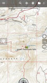
You can add "waypoints" to remember a spot you have planned at the trail head. You can also record your tracks.
 

Attachments

  • 1434072127458.jpg
    1434072127458.jpg
    157.1 KB · Views: 175
I've been using Trimble Pro on my iPad and like it so far. You can create entire trips on your computer and send them to your device. You can also pre-download entire areas so when you lose cell service you're still good to go.
 
Last edited:
Does any of them allow you to add as a favorite trail to remember for later and upload existing maps to use to navigate around?

If you have a track and / or waypoints saved as a .kml or .kmz file, most good GPS apps will let you open and display that data on top of the map. It's really handy, especially if the trail isn't marked on the map. I've done it in both apps I've used. If you check the Youtube channels of Backcountry Navigator or GPS Essentials, they will show you how to do it.

Mind you, if I were to recommend one over the other, I'd say use Backcountry Navigator mainly because (like olram30 mentioned) there are more map sources available from within the program that are useful, and it's much easier to cache them for offline use from within the app. You basically choose the map source you want, select the area you want to cache, and hit save.

With GPS Essentials, the only map sources within the app I found useful was Google satellite and topo views, but they couldn't be cached and you can only use them when you have a signal. The only really useful way to add maps to it was to use Google Earth, paste in a high res map image (basically a digital copy of what a good map store would print out for you) align the corners of the image to their correct coordinates, save that as a .kml or .kmz, transfer it to the phone, and open it in the app. It's good if you have a very specific map you want to use (I used it for range and training area maps at work), but it's a lot of extra work just for the topo. That's why I ended up switching to Backcountry Navigator.
 
I have been using Avenza PDF Maps its free and has topo maps for free. Download the maps for the area you are going to and it works without cell service.
 
Onboard GPS??

Hey guys, yes I have a stock nav in my jk but I've seen over and over again that guys were sticking GPS units in their rigs for Offroad trails that you wouldn't get on your regular nav. Any preference? Looking into getting on instead of having 30 different maps lol...
 
I believe the Bad Elf is still around, I have one for my iPad mini that works great with foreflight. Haven't found a street map app that works well though.
 
I believe the Bad Elf is still around, I have one for my iPad mini that works great with foreflight. Haven't found a street map app that works well though.

Yeah I use mine for foreflight too. They have a road map section too. Gotta upgrade to the stratus ADSB one of these days though.
 
I use Gaia with iPad mini and I'm pretty happy with it. You can download maps beforehand so if you don't have cell service, you'll still see where you're at. My iPad does have cell capabilities but I just use it for the GPS component
 
Backcountry GPS who's got em? What do you have?

My wife and i started looking at some backcountry GPS's, just wanted to know what you guys/ gals are using? Thanks!
 
My wife and i started looking at some backcountry GPS's, just wanted to know what you guys/ gals are using? Thanks!

I have the Garmin Etrex20 for backpacking. It's not one you can mount in the vehicle like an in-dash, but I use it on the Jeep trails in my hand when I need to. What I like about it is that you can download satellite images to it and it's a good priced unit. The only thing I don't like is that the screen is really small.
 
Top Bottom